 MozambiqueDiscover Mozambique's Indian Ocean coast, Portuguese-era history, Makonde and marrabenta culture, and seafood dishes…
DESTINATION
Kiribati
Kiribati travel guide covering where Kiribati is, its history, culture and traditions, and its signature food, from the Gilbert Islands to Kiritimati.
📅 Last updated:
🌍 Quick Facts

Kiribati at a glance
Capital: Tarawa (South Tarawa)
Currency: Australian dollar (AUD)
Language: English (official) and I-Kiribati (Gilbertese)
Population: About 119,000 (2020 census: 119,438)
Time zone: UTC+12 (Gilbert Islands), UTC+13 (Phoenix Islands), UTC+14 (Line Islands)
Calling code: +686
Internet domain: .ki
Main airport: Bonriki International Airport (TRW), South Tarawa
Best time to visit: June to October (dry season, October driest on Tarawa); wet season November to April
📍 Kiribati Map
🖼️ Kiribati: Location, History, Culture & Food
✨ Complete Travel Guide
Where Is Kiribati Located?
Kiribati is an island country in the central Pacific Ocean, roughly halfway between Hawaii and Australia. Its 33 coral islands straddle the Equator in three groups, the Gilbert, Phoenix and Line Islands, and the capital, Tarawa, lies in the Gilbert Islands.
Last checked: November 2026
Kiribati has one of the most unusual shapes of any country. Its land area is only about 811 square kilometres, yet the islands are scattered across roughly 3.5 million square kilometres of ocean. The country has no land borders, and it is one of the few that lies in all four hemispheres: north and south of the Equator, and east and west of the 180th meridian.
The Gilbert Islands in the west are home to most of the population, including South Tarawa, the main urban area. The Phoenix Islands lie in the centre of the country and are almost entirely uninhabited. The Line Islands stretch across the east and include eight islands, only three of which are inhabited: Kiritimati, Teraina and Tabuaeran. Kiritimati, also called Christmas Island, is the largest coral atoll in the world by land area. Banaba, a raised limestone island between Nauru and the Gilberts, stands apart from the atolls around it. In total, 21 of Kiribati’s 33 islands are inhabited.
Nearly every island is a low-lying ring of coral around a lagoon, and apart from Banaba, very little land rises more than three metres above sea level. Kiribati also spans three time zones: UTC+12 in the Gilberts, UTC+13 in the Phoenix Islands and UTC+14 in the Line Islands. In 1995 the country moved the International Date Line to the east so that all its islands share the same calendar day. To decide where to go, see our guide to the best places to visit in Kiribati and the best time to visit Kiribati.
Introduction to Kiribati
Kiribati, officially the Republic of Kiribati and pronounced kee-ree-bass, is a Pacific island nation of about 119,000 people (2020 census). Tarawa is the capital, English is the official language, I-Kiribati is widely spoken, and the Australian dollar is the currency. Its only UNESCO World Heritage site is the Phoenix Islands Protected Area.
Last checked: November 2026
The name Kiribati is the local rendering of Gilberts, taken from the main island chain, and it was adopted when the country became independent on 12 July 1979. The people are called I-Kiribati, and the national motto, Te Mauri, te Raoi ao te Tabomoa, means Health, Peace and Prosperity. Kiribati is a presidential republic with a House of Assembly, and traffic drives on the left. Before you plan a trip, read our guide to Kiribati visa requirements.
The economy is small and relies mainly on fisheries and copra exports, because phosphate mining ended around independence. Most people live in the Gilbert Islands, and more than half of the population lives on Tarawa Atoll, where islets are linked by causeways.
The Phoenix Islands Protected Area was inscribed on the UNESCO World Heritage List in 2010 and is one of the largest marine protected areas in the Pacific. Read the official description on the UNESCO page for the Phoenix Islands Protected Area, and see the national tourism board’s Visit Kiribati website for official visitor information.
- Official name: Republic of Kiribati
- Capital: Tarawa (South Tarawa is the most populated area)
- Languages: English (official) and I-Kiribati (Gilbertese)
- Currency: Australian dollar (AUD)
- Time zones: UTC+12, UTC+13 and UTC+14
- Calling code and domain: +686 and .ki
History of Kiribati
Micronesian navigators settled the Gilbert Islands long before European contact. Britain declared a protectorate over the islands in 1892 and made them a colony in 1916. After the Battle of Tarawa in 1943, the Gilbert Islands became independent as Kiribati on 12 July 1979.
Last checked: November 2026
Early settlement
The ancestors of the I-Kiribati were Micronesian navigators who reached the Gilbert Islands from the west. Sources differ on the exact timing, with estimates ranging from roughly a thousand to several thousand years ago. Later arrivals from Fiji and Tonga, around the 14th century, mixed with the older communities and helped shape traditional I-Kiribati society.
Protectorate, phosphate and colony
The name Gilbert Islands dates to about 1820, when Russian and French navigators named the chain after the British captain Thomas Gilbert. The Gilbert and Ellice Islands became a British protectorate in 1892, and Banaba was annexed around 1900 after high-grade phosphate was found there. The Gilbert and Ellice Islands Colony was formed in 1916, Kiritimati joined it in 1919 and the Phoenix Islands in 1937. Phosphate mining on Banaba continued until independence and left the island devastated, and most Banabans were resettled on Rabi Island in Fiji in the 1940s.
The Battle of Tarawa
Japan occupied the Gilbert Islands soon after the attack on Pearl Harbor. In November 1943, United States Marines landed on Betio, in Tarawa Atoll, and fought for about 76 hours between 20 and 23 November. It was one of the bloodiest battles in the history of the US Marine Corps and a turning point in the Central Pacific campaign.
Independence
The Ellice Islands separated from the colony in 1975 and became Tuvalu in 1978. The Gilbert Islands moved to internal self-government and then to full independence as Kiribati on 12 July 1979, with Ieremia Tabai as the first president. Soon afterwards, in the Treaty of Tarawa, the United States gave up its claims to 14 islands in the Line and Phoenix groups.
Culture and Traditions of Kiribati
I-Kiribati culture centres on family, respect for elders and the maneaba, the traditional meeting house where communities gather to decide, celebrate and share food. Dance, song, weaving and canoe sailing remain central to daily life and to national celebrations such as Independence Day.
Last checked: November 2026
The maneaba
The maneaba (te mwaneaba) is the heart of village life, a large open-sided hall where families meet to discuss community matters, hold celebrations and welcome guests. A gathering and feast there is called a botaki. Respect, known as te karinerine, runs through family and community life, and elders are honoured as guardians of knowledge and tradition. Hospitality to guests and respect for other people’s property are strongly valued, so visitors should follow local guidance on where to sit and how to behave inside a maneaba.
Dance, music and canoes
Te kaimatoa, the dance of strength, is the most widely practised dance in Kiribati today. Dancers strike short sticks in time with a song, and a wooden box is used as percussion in formal performances of te kaimatoa and the hip dance, te buki. Other forms, such as te rebwe, rely on clapping and stepping. Annual canoe racing has helped keep the traditional sailing canoe alive, and Independence Day on 12 July brings canoe races, dance and communal feasts.
Language, faith and holidays
I-Kiribati is the language of everyday life, and English is the official language. Most people are Christian, and a small Bahá’í community made up about 2.1 percent of the population in the 2020 census. Independence Day on 12 July is the main national holiday, and Good Friday, Easter, Christmas and Boxing Day are also celebrated.
Food and Cuisine of Kiribati
I-Kiribati cooking is built on fresh fish and a few hardy atoll crops, including coconut, taro, breadfruit and pandanus. Rice is a common staple today, and feasts often centre on roast pig. Signature tastes include palu sami, raw tuna and babai.
Last checked: November 2026
Soils on coral atolls are thin, so food traditions revolve around what the sea and a few resilient plants provide. Local names and recipes vary from island to island, and the dishes below are the ones most often associated with Kiribati.
- Palu sami: a creamy dish of coconut cream and taro leaves, often flavoured with curry powder and cooked with chicken or pork.
- Fresh raw tuna: sashimi-style fish, sometimes marinated in coconut milk, a staple for coastal communities.
- Babai: giant swamp taro, grown in pits and a prized food at feasts.
- Pandanus fruit: eaten with coconut cream, especially in the southern islands.
- Roast pig: the centrepiece of a feast, which is considered small without one.
- Whole roasted fish: served at celebrations such as Independence Day.
- Breadfruit: a starchy staple that can be roasted or boiled.
- Coconut: eaten fresh and used for its cream in many dishes.
- Rice with fish: a simple everyday meal of rice with grilled or fried fish.
- Pumpkin, papaya and bananas: local fruit and vegetables that round out village meals.
- Chinese-influenced dishes: Chinese cooking has left a clear mark on the country’s food culture.
Meals are communal, and guests are usually offered food first. Fresh seafood is the best way to start, and it is worth asking a local host which dishes are most typical on their island.
When you are ready to plan, use our Kiribati itinerary for 3 to 10 days, find where to stay in Kiribati, check flights to Kiribati and read how to get around Kiribati by bus, ferry and plane.
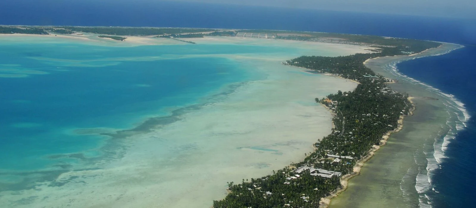
Photo credit: “South Tarawa from the air”, Government of Kiribati, via Wikimedia Commons, licensed under CC BY 3.0.
Explore Kiribati Travel Guides
Explore our detailed guides to plan every part of your Kiribati trip.
Kiribati: Best Places
The best places to visit in Kiribati: Betio war sites, South Tarawa, North Tarawa, Abaiang, Kiritimati and the Phoenix Islands, with access...
View Guide ›Kiribati: Best Time to Visit
The best time to visit Kiribati is usually the dry season from June to October. See seasons, regional climate differences, public holidays,...
View Guide ›Kiribati: Flights
Flights to Kiribati mostly land at Bonriki Airport on Tarawa via Nadi, Brisbane or Honiara. See airports, airlines, arrival tips and a...
View Guide ›Kiribati: Getting Around
How to get around Kiribati: South Tarawa minibuses, North Tarawa and Abaiang ferries, Air Kiribati domestic flights, car and motorbike hire, driving...
View Guide ›Kiribati: Itineraries
Kiribati itinerary ideas for 3, 5, 7 and 10 days, covering South Tarawa, Betio, Abaiang and outer-island extensions, with realistic routes and...
View Guide ›Kiribati: Visa
Kiribati visa requirements for tourists: who is visa exempt, passport validity, how to apply, fees, extensions, border checks and the departure tax,...
View Guide ›Kiribati: Hotels
Where to stay in Kiribati: South Tarawa, Betio, North Tarawa and Abaiang compared, with budget options, booking tips and what to confirm...
View Guide ›Explore Kiribati Tours
Discover guided tours and adventures in Kiribati. Compare itineraries, prices and traveller reviews on TourRadar before you book.
Guided tours & deals
Affiliate partner · Globe Navo may earn a commission from qualifying bookings at no extra cost to you.
❓ Kiribati FAQ
Where is Kiribati located?
Kiribati is an island country in the central Pacific Ocean, roughly halfway between Hawaii and Australia. Its 33 coral islands lie in the Gilbert, Phoenix and Line groups and straddle the Equator. The capital, Tarawa, is in the Gilbert Islands.
What is the capital of Kiribati?
The capital of Kiribati is Tarawa, in the Gilbert Islands, and South Tarawa is its most populated area. More than half of the country population of about 119,000 lives on Tarawa Atoll, where the islets are linked by causeways.
What language is spoken in Kiribati?
English is an official language, and I-Kiribati, also called Gilbertese, is the language of everyday life. Learning a few I-Kiribati greetings is a respectful gesture when you visit villages and share a meal in a maneaba.
What currency does Kiribati use?
Kiribati uses the Australian dollar (AUD) as its currency. Payment options can differ between Tarawa and the outer islands, so confirm how your accommodation and tour operators take payment before you travel, and carry some cash as a backup.
What is Kiribati known for?
Kiribati is known for its 33 coral islands spread across the Equator, the Phoenix Islands Protected Area, its only UNESCO World Heritage site, and the 1943 Battle of Tarawa. It is also known for maneaba gatherings, te kaimatoa dance and fresh tuna.
Plan Your Trip to Kiribati
Your Next Adventure in Kiribati Awaits!
Explore Deals →🎁 Best deals for Kiribati
Offers from trusted travel stores for your Kiribati trip. Compare a few options before you book, and check each store's terms for the final price.
Browse by type: Hotel deals · Flight deals · Travel eSIM · Car rental
More destinations to explore
MozambiqueDiscover Mozambique's Indian Ocean coast, Portuguese-era history, Makonde and marrabenta culture, and seafood dishes…
 CameroonCameroon at a glance: where it is, what it is known for, its history,…
 DjiboutiDjibouti is a Red Sea nation on the Horn of Africa, known for Lac…